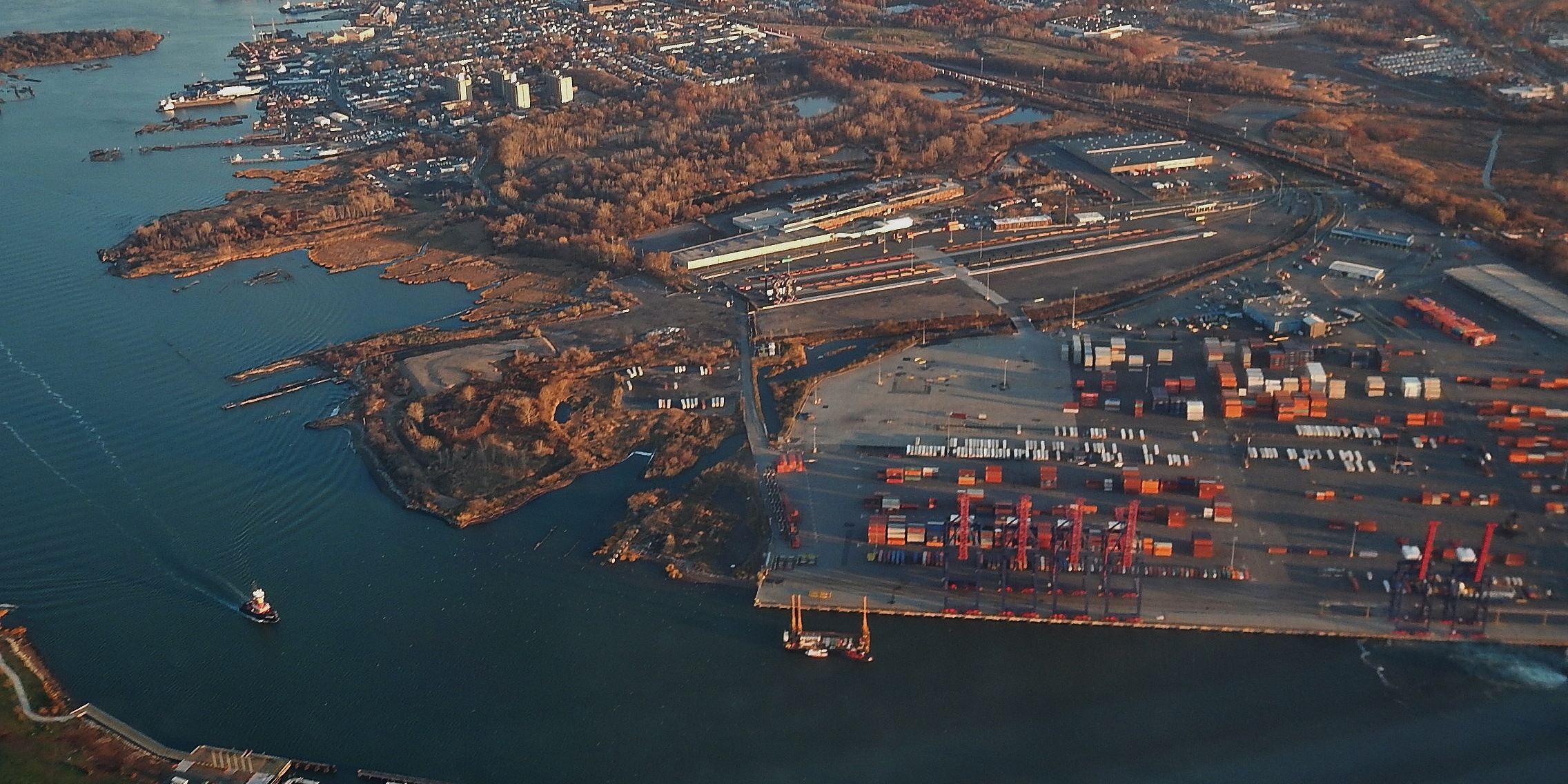
Aerial view of the Howland Hook container terminal on the Arthur Kill, Staten Island
Development Tracker — West Shore & Port Richmond

What's Being Built on Staten Island's West Shore & Port Richmond? A $185 Million Plant Upgrade, an Unfunded Busway & a Port Built for Growth

Hush Street tracks what's changing on Staten Island's western North Shore and West Shore: the Port Richmond wastewater plant upgrade, the unfunded North Shore busway, the Richmond Terrace rezoning study, Howland Hook's expansion and the area's few housing and school projects.
12
Projects Tracked
$185M
Port Richmond Plant Upgrade Under Way
~25
Apartments in the Largest Housing Filing
1
Under Construction
Oct. 2026
Updated
Watch → Stop-Work Order Record at 400 Lake Ave. North Shore Busway Unfunded
What’s Changing
→
The city broke ground on a $185 million upgrade of the Port Richmond wastewater plant.Oct. 2026
→
DOB issued a demolition permit for the Davidson Street truck-yard site in Mariners Harbor.Oct. 2026
→
A business coalition urged the governor to fund the North Shore busway.Mar. 2026
Under Construction1
Stop-Work Order Record1
Permitted2
Approved1
Planning, Unfunded or Filed5
Stalled1
Completed1
See full project list →

Hush Street is tracking what’s being built on Staten Island’s western North Shore and West Shore: Port Richmond, Mariners Harbor, Arlington, Graniteville, Bloomfield and Travis.

This is Staten Island’s working waterfront, home to the Howland Hook container terminal and the Matrix logistics park, and most of the change here is infrastructure, industry and planning rather than housing. Hush Street’s review of DOB filings found the largest multifamily filing in the area is about 25 apartments.

The biggest active project is public: a $185 million modernization of the Port Richmond wastewater plant broke ground in October 2026. The North Shore busway has finished its environmental review but is not funded to be built, and City Planning’s Richmond Terrace Corridor plan is still at the community-meeting stage. In May 2024 the Port Authority took full ownership of the Howland Hook terminal to support its operator’s $200 million expansion.

Where DOB records and press reports disagree, both are given. A permit is not treated as proof that construction has started.

Project Location Status
1North Shore Bus Rapid Transit St. George to Arlington Unfunded
2Richmond Terrace Corridor Plan Jersey St. to the Bayonne Bridge In Planning
3Mariners Marsh & Arlington Marsh Richmond Terrace & Western Ave. In Planning
4Port Richmond Wastewater Plant Upgrade Richmond Terrace, Port Richmond Under Construction
5Port Liberty New York (Howland Hook) Western Ave., Port Ivory Approved
6Matrix Global Logistics Park West Campus Gulf Ave., Bloomfield No Recent Activity
760-82 Davidson Street Truck Yard Davidson St., Mariners Harbor Permitted
8400 Lake Avenue Lake Ave. at Forest Ave. Stop-Work Order Record
9534 South Avenue Retail South Ave. at Forest Ave. Stalled
1063 Church Street Church St. at Port Richmond Ave. Filed (Plan Review)
1125 Greenleaf Avenue School Greenleaf Ave., Port Richmond Permitted
12Staten Island Rise Academy (P.S. 121) Victory Blvd., Travis Completed

Transit, Planning & the Waterfront

A busway still waiting for money, a rezoning study, a closed park and the area’s largest construction job.

1

North Shore Bus Rapid Transit

Google Maps of Port Richmond, Staten Island, NY
The North Shore between St. George and Arlington, via Google Maps. — Imagery: Google Maps
Address/LocationFormer North Shore Railroad right-of-way, St. George Terminal to Arlington and West Shore Plaza
Developer/ApplicantMetropolitan Transportation Authority
ProjectA bus rapid transit line running mostly on a dedicated busway along the abandoned North Shore rail line, with 14 stops including a station at Mariners Harbor (MTA, SILive).
StatusUnfunded
Latest UpdateThe MTA completed the final environmental review in January 2024, but its 2025-2029 capital plan commits only to further evaluation and development. In March 2026 a business coalition urged Gov. Kathy Hochul to fund construction in the next capital plan, SILive reported.

Environmental Review Done, No Money to Build

The MTA still lists the project as in planning.

Sources: MTA; Staten Island Advance / SILive (Mar. 2026)

2

Richmond Terrace Corridor Plan

Google Maps of Richmond Terrace, Port Richmond, Staten Island, NY
Richmond Terrace along the Kill Van Kull, via Google Maps. — Imagery: Google Maps
Developer/ApplicantNYC Department of City Planning
ProjectA City Planning study of the Kill Van Kull waterfront from Jersey Street to the Bayonne Bridge, aiming for mixed-use neighborhood centers, maritime jobs, waterfront access and permanently affordable housing.
StatusIn Planning
Latest UpdateCity Planning lists the plan as in progress, holding community meetings to turn its 2023 report into a land-use framework for new zoning. No rezoning application has been certified.

A Rezoning Still Being Shaped

The last dated public meeting on City Planning’s page is from December 2023. The plan is separate from the North Shore plans for St. George and Stapleton.

Sources: NYC Department of City Planning (accessed Oct. 2026)

3

Mariners Marsh & Arlington Marsh

Google Maps of Mariners Marsh Park, Staten Island, NY
Mariners Marsh and Arlington Marsh, via Google Maps. — Imagery: Google Maps
Address/LocationMariners Marsh Park
Developer/ApplicantNYC Parks with the NYS Department of State
ProjectA master plan to reopen Mariners Marsh Park and restore Arlington Marsh, funded in part by a state Environmental Protection Fund grant (NYC Parks).
StatusIn Planning
Latest UpdateNYC Parks has published the master plan; no construction timeline has been announced. The state awarded more than $1 million in 2022 for trail and habitat design, SILive reported.

A Park Closed Since 2006

The park has been closed for environmental investigation for years.

Sources: NYC Parks; Staten Island Advance / SILive (Dec. 2022)

4

Port Richmond Wastewater Plant Upgrade

Google Street View of Port Richmond Wastewater Treatment Plant, 1801 Richmond Terrace, Staten Island, NY
Port Richmond Wastewater Plant Upgrade, via Google Street View. — Imagery: Google Street View
Address/Location1801 Richmond Terrace
Developer/ApplicantNYC Department of Environmental Protection
ProjectA $185 million design-build modernization of electrical, mechanical and control systems with flood walls and deployable barriers, on top of $279 million of other upgrades at the plant (Mayor’s Office).
StatusUnder Construction
Latest UpdateThe city broke ground on Oct. 21, 2026, with completion expected in summer 2029. DOB separately permitted a $40 million aeration-tank piping job in 2025.

Flood-Proofing a Treatment Plant

Infraday reported the plant serves about 200,000 residents.

Sources: NYC Mayor's Office (Oct. 2026); Infraday (Oct. 2026); NYC DOB NOW job S01227316-I1 (2025)

Port & Industry

A container terminal set to grow, a warehouse plan with no recent public steps and a truck yard on the waterfront.

5

Port Liberty New York (Howland Hook)

Google Street View of Howland Hook Marine Terminal, 300 Western Avenue, Staten Island, NY
Port Liberty New York (Howland Hook), via Google Street View. — Imagery: Google Street View
Address/Location300 Western Avenue
Developer/ApplicantPort Authority of New York and New Jersey (owner); CMA CGM (operator)
ProjectAn expansion of the 345-acre container terminal, funded by operator CMA CGM’s $200 million commitment, to raise capacity by 50 percent to about 750,000 lifts a year over seven years (Port Authority).
StatusApproved
Latest UpdateThe Port Authority’s board authorized full ownership of the terminal in May 2024, with the city transferring 225 acres. Hush Street has not found a public report that the wharf and berth work has started.

A Port Built for Growth

As Port Authority property, the terminal’s work does not appear in city building records.

Sources: Port Authority of NY & NJ (May 2024); Office of the Governor

6

Matrix Global Logistics Park West Campus

Google Street View of 530 Gulf Avenue, Staten Island, NY
Matrix Global Logistics Park West Campus, via Google Street View. — Imagery: Google Street View
Address/Location530-534 Gulf Avenue
Developer/ApplicantMatrix Development Group
ProjectTwo warehouses totaling about 1.78 million square feet with 1,010 parking spaces on a wetland-laden Arthur Kill parcel next to the existing Matrix park (NYSDEC).
StatusNo Recent Activity
Latest UpdateThe state opened an environmental review with a scoping notice in August 2022. Hush Street found no draft review, permit or DOB building filing since.

A Warehouse Plan Gone Quiet

IKEA left its 975,000-square-foot warehouse in the existing Matrix park in the third quarter of 2025, Crain’s reported.

Sources: NYS Department of Environmental Conservation draft scope (2022); Crain's New York Business (Oct. 2025)

7

60-82 Davidson Street Truck Yard

Google Street View of 60 Davidson Street, Staten Island, NY
60-82 Davidson Street Truck Yard, via Google Street View. — Imagery: Google Street View
Address/Location60 Davidson Street
Developer/ApplicantCriterion Group
ProjectConversion of a waterfront industrial site into commercial vehicle storage, with a repair shop at 82 Davidson Street (DOB).
StatusPermitted
Latest UpdateDOB issued a demolition permit for 46 Davidson Street on Oct. 22, 2026 and has approved the demolition of a 40,174-square-foot building at 60 Davidson and the change of use to vehicle storage.

Outdoor Storage on the Waterfront

Industrial outdoor storage yards like this one are a growing use on the West Shore.

Sources: NYC DOB NOW jobs S01369876-I1, S01363556-I1 and S01288993-I1 (Oct. 2026); IOS List (June 2024)

Port Richmond, Mariners Harbor & Graniteville

A troubled hotel conversion, a retail plan on wetlands, the area’s biggest apartment filing and two schools.

8

400 Lake Avenue

Google Street View of 400 Lake Avenue, Staten Island, NY
400 Lake Avenue, via Google Street View. — Imagery: Google Street View
Address/Location400 Lake Avenue
Developer/ApplicantKevin Gau (owner, SILive); Angelo Ng & Anthony Ng Architects
ProjectAn enlargement of a two-story former VNA building to seven stories and 73 feet. Plans described in 2022 called for a 43-room hotel plus a laundromat, adult day care and medical office (SILive).
StatusStop-Work Order Record
Latest UpdateDOB records show a stop-work order on Aug. 11, 2025, a violation on April 28, 2026 for working against it after concrete was placed at the second floor, and a June 2026 crane violation. Hearings are scheduled into 2027.

Work Against a Stop-Work Order

The records do not show whether the order has since been lifted. The building is across from P.S. 22.

Sources: NYC DOB NOW job S00574589-I1 and ECB records (Sept. 2026); Staten Island Advance / SILive (Oct. 2022)

9

534 South Avenue Retail

Google Street View of 534 South Avenue, Staten Island, NY
534 South Avenue Retail, via Google Street View. — Imagery: Google Street View
Address/Location534 South Avenue
Developer/ApplicantJosif A LLC
ProjectA five-building, 219,377-square-foot retail complex on a long-contested wetlands site once planned for a BJ’s (ZAP).
StatusStalled
Latest UpdateCity Planning renewed the special permit for a second time in May 2025, but SILive found the site still overgrown and BJ’s would not say whether it still plans to open. The three DOB building filings have been in objections since January 2024.

Approved Again, Still Empty

An earlier version of the plan described about 223,000 square feet.

Sources: NYC Planning ZAP 2025R0102; Staten Island Advance / SILive (May 2025); NYC DOB NOW job S08025814-I1 (accessed Oct. 2026)

10

63 Church Street

Google Street View of 63 Church Street, Staten Island, NY
63 Church Street, via Google Street View. — Imagery: Google Street View
Address/Location63 Church Street, also 41 Port Richmond Avenue
Developer/ApplicantALVM Realty
ProjectA six-story building with ground-floor retail and affordable apartments. The DOB filing’s description says 25 apartments; its unit field says 20.
StatusFiled (Plan Review)
Latest UpdateThe application, filed on Feb. 26, 2026, was in DOB objections at its last action on March 20. A 2021 filing for a four-story, 15-unit building on the site was disapproved.

The Area's Largest Apartment Filing

It is one of very few multifamily filings in Port Richmond’s center.

Sources: NYC DOB NOW job S01324750-I1 (Mar. 2026); NYC DOB BIS job 520350833 (2021)

11

25 Greenleaf Avenue School

Google Street View of 25 Greenleaf Avenue, Staten Island, NY
25 Greenleaf Avenue School, via Google Street View. — Imagery: Google Street View
Address/Location25 Greenleaf Avenue
Developer/ApplicantNYC School Construction Authority; Gannett Fleming
ProjectA new three-story, 58-foot public school building of about 60,600 square feet (DOB).
StatusPermitted
Latest UpdateDOB issued the new-building permit on March 11, 2026, with foundation and structural permits through April and plan amendments approved in September.

A School Without a Name Yet

The school’s name, seat count and opening year have not been made public.

Sources: NYC DOB NOW job S01075004-I1 (Sept. 2026)

12

Staten Island Rise Academy (P.S. 121)

Google Street View of 4074 Victory Boulevard, Staten Island, NY
Staten Island Rise Academy (P.S. 121), via Google Street View. — Imagery: Google Street View
Address/Location4074 Victory Boulevard
Developer/ApplicantNYC School Construction Authority; Mitchell Giurgola Architects
ProjectA new three-story school building that became the main site of Staten Island Rise Academy, a District 75 special-education school (NYC Public Schools, SILive).
StatusCompleted
Latest UpdateThe building opened for the 2025-26 school year.

A New Special-Education School

DOB records list the building as P.S. 121.

Sources: NYC Public Schools; Staten Island Advance / SILive (May 2025); NYC DOB NOW job S00688101-I1

What We're Watching Next

Funding for the North Shore busway in the next MTA capital plan, the zoning recommendations from the Richmond Terrace Corridor plan, the start of wharf work at Howland Hook, any movement on the Matrix West Campus and the 534 South Avenue site, and the status of the stop-work order at 400 Lake Avenue are next.

Hush Street is also tracking St. George and the eastern North Shore and Staten Island’s Mid-Island and South Shore.

Header photo: the Howland Hook container terminal on the Arthur Kill, 2014, by qwesy qwesy, via Wikimedia Commons, CC BY 3.0.

By Updated Built from city filings and published reporting. About Hush Street